Overview
The Google Earth Engine (GEE) has massive computational resources, entire archives of data from many popular satellites, and an API that allows us to run many common image processing tasks [1]. For this reason, the GEE is an excellent resource for finding and preprocessing time series of satellite data to the point where it is “analysis ready”. Data that is “analysis ready” is generally considered to be preprocessed to a minimum set of requirements and organized to facilitate user analysis without much effort ([2][3] and CEOS):
In this package, “Analysis Ready Data” (ARD) means:
Preprocessed to a high enough level to be consistent over time (e.g., surface reflectance)
Reprojected or projected into some projection suitable for large scale analysis
Clipped into non-overlapping tiles, usually by combining sensor acquisition “paths” and “rows”. For Landsat data, this also means removal of the “north-south” overlap present in WRS-2 scenes.
Stored in a format suitable for time series analysis (e.g., NetCDF4)
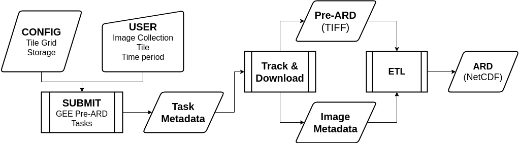
The CEDAR tool has a number of functions to accomplish the first 3 steps on
the GEE for a given sensor image collection. These functions generate “pre-ARD”
images (ee.Image) and “image metadata”, which is required because images
exported from the Earth Engine after preprocessing lose their basic metadata
information (sensor, acquisition times, etc). The CEDAR application also
generates “tracking metadata” about the orders it creates. The
“tracking metadata” allows us to download the “pre-ARD” and “image metadata”
at a later point for further processing into ARD.
There are 6 main steps to creating this Analysis Ready Data using CEDAR and the Google Earth Engine (GEE).
Authenticating to services
Configuration file creation
“Pre-ARD” order submission
Conversion of “pre-ARD” and “image metadata” into ARD
Deleting of tracked “pre-ARD” data from storage
Supported Image Collections
Currently, only Landsat Collection 1 Surface Reflectance data are supported.
Sensor |
Image Collection |
|---|---|
Landsat |
LANDSAT/LT04/C01/T1_SR LANDSAT/LT05/C01/T1_SR LANDSAT/LE07/C01/T1_SR LANDSAT/LC08/C01/T1_SR |
Limitations
This tool is useful for rapidly creating remote sensing time series that are “analysis ready” by using the free (to non-commercial users) resources of the Google Earth Engine. Accomplishing this, however, requires that you have a Google service (Google Drive or Google Cloud Storage) to use as an export destination. Specifically, this tool creates large amounts of data that you’ll need to be able to store and download, which may incurr costs.
Storage on cloud services like Google Cloud Storage is comparatively cheap compared to charges incurred from downloading (“egress” charges), which may be considerable. Storage on the Google Drive is paid for as a storage cap (e.g., 1 terrabyte) rather than being billed for specific usage (e.g., 1 TB for a month). Downloading from the Google Drive is not metered and does not appear to have a quota. Many institutions may also have “G Suite” accounts with large or “unlimited” storage, making Google Drive a good storage choice in these cases.
References
- 1
Noel Gorelick, Matt Hancher, Mike Dixon, Simon Ilyushchenko, David Thau, and Rebecca Moore. Google earth engine: planetary-scale geospatial analysis for everyone. Remote Sensing of Environment, 202:18–27, 2017.
- 2
John Dwyer, David Roy, Brian Sauer, Calli Jenkerson, Hankui Zhang, and Leo Lymburner. Analysis ready data: enabling analysis of the landsat archive. Remote Sensing, 10(9):1363, 2018.
- 3
Adam Lewis, Simon Oliver, Leo Lymburner, Ben Evans, Lesley Wyborn, Norman Mueller, Gregory Raevksi, Jeremy Hooke, Rob Woodcock, Joshua Sixsmith, and others. The australian geoscience data cube—foundations and lessons learned. Remote Sensing of Environment, 202:276–292, 2017.